
CliffMetrics for HPC
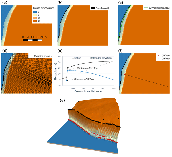
CliffMetrics (Automatic Cliff Metrics delineation) delineates the location of the coastline, coastline normals, and cliff top and toe location along these normals.
Contents
This text will be replaced automatically with the TOC (h4, h5) in the published version (not visible in the Preview). See class episode-body to change format.
Why it matters?
CliffMetrics for Linux matters because running cliff‑top and cliff‑toe extraction at national scale requires a workflow that is fast, repeatable, and able to run on high‑performance computing systems. While the SAGA GIS version of CliffMetrics can be automated through the SAGA terminal, very large areas quickly push beyond what a desktop setup can handle. The Linux version was created to solve this problem: it lets users run CliffMetrics programmatically, efficiently, and in parallel on clusters and HPC environments where Linux is the standard operating system. This makes it possible to process thousands of kilometres of coastline in a consistent, transparent way — a capability that is essential for national assessments and long‑term coastal planning.
This software and additional supporting material can be found in the official repository and in dedicated LinkedIn URL shown below.
Related content
No items found.
Thank you! Your submission has been received!
Oops! Something went wrong while submitting the form.

coastalgeohazardsexperts.co.uk
Coastal Geohazards Experts Ltd. Registered Number: SC873383. Registered in Scotland. Correspondence address: Murchison House, 10 Max Born Crescent, EH9 3BF, Edinburgh, United Kingdom. Copy Right (c), Coastal Geohazards Experts Ltd, 2026. All rights reserved. "Dr Andres Payo" is a trading name of Coastal Geohazards Experts Ltd.